
Pahrump Neighbors: Block Sources
A block-level search in Pahrump starts with public land and address context. Nye County’s map layers can place a known address beside parcels, streets, boundaries, and precincts. The Assessor can supply an assessment record for a parcel. The Recorder can add a recorded-document trail. Voter records and local organizations have their own access rules. Use each source for what it actually documents, and do not turn an owner name, map label, or organization contact into a claim about every person who may live nearby.
| Source | What It Shows About a Block | Access |
|---|---|---|
| Nye County GIS FeatureServer | Addresses, parcels, streets, boundaries, precincts, and planning layers around a mapped point | Official online map service; layer fields vary. |
| Nye County Assessor Property Inquiry | Assessment association, parcel ID, and address or owner search results | Public inquiry; owner and occupancy are different facts. |
| Nye County Recorder index | Recorded parties, instruments, document numbers, and legal-record trails | Public index begins with a finding aid, with separate copy routes. |
| Nye County Clerk voter records | Statutory registration-list access, subject to protected and withheld fields | Request through the Clerk under Nevada election law. |
| Public community organizations | Organization contacts, services, events, or boundaries where a source publishes them | Use the organization’s public contact path; no membership is implied. |
The distinction between owner and occupant matters. An assessor or Recorder result can identify a party tied to a parcel or document, but it does not verify who is currently present at the address. A postal label, a PO Box, a map point, and a parcel polygon also answer different questions. Keep the source date with every result, especially when following a Pahrump neighborhood trail over time.
Pahrump GIS Layers Around a Block
The official Nye County Planning FeatureServer is the most detailed public map source found for a Pahrump block. Its layers include addresses, permits, streets, easements, parcels, county and town boundaries, commissioners districts, voting precincts, fire stations, schools, zoning, and planning designations. The service supports map queries using a layer, field conditions, object IDs, geometry, and selected output fields. A polygon is still map data, not an ownership record, survey, or proof that a person occupies a nearby address.
Open the Nye County GIS FeatureServer to inspect the official layer list before relying on a particular map field.
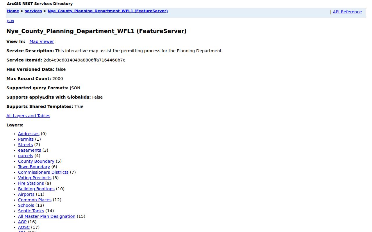
The visible layer catalog shows why an address, parcel, precinct, and planning boundary should not be collapsed into one label for Pahrump neighbors.
Use the map to identify context first. A boundary overlay may show whether a point is in a town or county area, while a street layer can help distinguish similar local names. Then confirm a person or owner only through the Assessor, Recorder, or other custodian whose record has the right purpose. Note: Map labels and parcel shapes need a source date and layer context before they support any neighborhood conclusion.
Pahrump Neighbors and Parcel Names
The Assessor’s Property Inquiry provides owner-name, parcel, address, personal-property, and advanced-value searches. Its help text says parcel IDs use eight digits without dashes. Search fields can narrow by owner, house range, street, city, and ZIP. The resulting card is an assessment record. It can help connect a public address to a parcel identifier or identify the name recorded with the assessment, but a mailing address can differ from the situs address and either field may be stale.
Recorded documents add a separate legal trail. The Recorder’s public index is advertised from the previous day back to 1986, with earlier records handled through the office. Search names in alternate spellings and name order. A recorded party may be a grantor, grantee, trustee, lienholder, beneficiary, or signer. That role is not the same as a Pahrump neighbor or a current occupant. The Recorder’s public index is a finding aid, and a document image or copy may use a separate access route.
Note: An owner, document party, mailing address, and current occupant are separate fields that should not be merged without independent support.
Pahrump Community Contacts Without Member Lists
Public community resources can be useful when the question is about a service, an event, a neighborhood institution, or an association boundary. They are not resident rosters. The research found no public member directory for Comstock Park HOA or NyE Communities Coalition. County planning and water documents can name associations, but an association name alone does not prove an address is within its current boundary or that a person belongs to it.
| Organization or record | Public contact or source | What to keep in mind |
|---|---|---|
| Comstock Park HOA | 151 Comstock Circle N, Pahrump; 775-990-4190 | The official site provides an owner portal and event calendar, not a public member directory. |
| NyE Communities Coalition | 1020 E Wilson Road, Pahrump; 775-727-9970 | It lists community organizations and agencies, not a public member roster. |
| Artesia Owners Association | Nye County planning document identifies 6601 Fox Avenue, Pahrump | Use the dated planning record to research the institution, not to identify members. |
| Cottonwoods Owners Association | Nye County planning document identifies PO Box 4313, Pahrump | A mailing contact is not an association-boundary map or a member list. |
See the NyE Communities Coalition’s public resource information for its current organization and agency contacts.

A community resource page can help identify local support or civic contacts without turning those contacts into a list of Pahrump neighbors.
Voter Records Around a Pahrump Block
Nevada election records should be handled as a separate statutory source. Nye County’s voter-registration material states that an actual, physical, or legal county residence is part of registration, while mailing addresses can differ. NRS 293.440 allows a person to request a registered-voter list from the county clerk at the statutory per-name fee. NRS 293.558 protects Social Security numbers, driver-license and identification numbers, and election email. Addresses and phone numbers can also be subject to written-request withholding rules.
The statewide voter-status portal is useful for the voter’s own status, but the research did not verify its live field labels. Do not use it as a block-search substitute. For a specific lawful request, contact the Nye County Clerk and identify the desired format and the protected fields to exclude. CAP fictitious addresses are excluded from the statewide list under NAC 293.476. A list entry remains a registration record, not proof of ongoing presence at a Pahrump address.
Note: A statutory voter-list request must exclude protected fields and should be limited to the record purpose and format actually needed.
Map a Pahrump Block and Its Parcels
The adjacent-parcel method keeps a neighborhood search tied to land records rather than guesses. Begin with a permitted public address or parcel. Use the GIS address and parcel layers to locate its mapped setting, then note neighboring parcel IDs and street names. Check boundary and precinct overlays as geographic context. Finally, verify a visible name through the Assessor or Recorder. The Pahrump street directory is the better route when the goal shifts from a small radius to a full named-street record chain.
- Locate the known address or parcel in the Nye County GIS address and parcel layers.
- Inspect the immediately surrounding parcel geometry, parcel IDs, street names, and relevant boundary or precinct layers.
- Run each parcel ID, address, or owner name through the Assessor inquiry and label the result as an assessment record.
- Use the Recorder index for a dated legal instrument when needed, then keep the document role and date attached to the name.
Address → GIS parcel and street context → adjacent parcel IDs → Assessor record → Recorder instrument is a useful research flow. It does not establish current occupancy or private household relationships.
Pahrump Neighborhood Geography and Neighbors
Geography changes the meaning of a search result. USPS delivery addressing, Assessor situs and mailing fields, and GIS address and parcel layers are three distinct systems. A delivery point may not match an assessor situs, and a mailing address may be a PO Box or another location. The GIS can also show whether a point lies near a named subdivision, a town or county boundary, a precinct, or a planning designation. Those layers explain place; they do not confirm a person’s residence.
The county map service can be especially useful for older subdivision names and street context. Research did not find an authoritative Pahrump street-renaming or renumbering crosswalk. Do not convert an old address into a current one without a county, GIS, Recorder, USPS, plat, or archival source that documents the link. For current delivery validation, use the official USPS lookup and preserve unresolved historic conversions as open research questions.
Note: A ZIP, parcel, subdivision, precinct, and Pahrump town or CDP boundary are separate geographic layers with different purposes.
Pahrump Neighbors Through Local Institutions
Town and community directories are most useful for finding an organization, program, or public contact near a Pahrump block. The Town of Pahrump community page provides civic and community resources, while the Pahrump Valley Chamber directory supports keyword, category, and A-Z organization searching. Neither source is a resident list. A business primary contact, organization representative, board participant, or historic subject should remain labeled by that role rather than recast as a confirmed neighbor.
The Pahrump Valley Chamber directory is another local discovery layer, with keyword, category, and A-Z controls. It should be used to locate businesses and community organizations, then verified through the responsible government, licensing, or organization source when status matters.
The Chamber’s public directory is an organization finder, not a roster of the people who live on a Pahrump block. Town community resources provide another public contact route, but neither source identifies private household membership.
Privacy Limits for Pahrump Neighbor Lookups
Official records and commercial neighbor tools are not interchangeable. County and state sources identify a custodian, date, record purpose, and access limits. Commercial tools may combine data from sources with different dates and provide no clear explanation for a particular result. Start with the official record when a parcel, association boundary, or voter-access question needs verification, and use the custodian’s correction or request route if the source appears inaccurate.
| Source type | Useful for | Limit to remember |
|---|---|---|
| Official parcel, GIS, Recorder, or election source | Checking a defined record, geography, document role, or statutory access path | Each record has its own purpose and can be dated, incomplete, or protected. |
| Commercial neighbor tool category | Only a possible lead to check against a custodian | Source dates, accuracy, and the basis for a result may be unclear. |
Nevada’s Confidential Address Program provides substitute addresses and mail forwarding for qualifying survivors. Protected voter fields, vital records, sealed court material, utility information, delivery information, and private household details should not be collected or published as block data. The Nevada Public Records Act supports defined requests to the correct custodian, subject to the laws that protect confidential information.
Lawful use. Pahrump neighbor research can support community awareness, reconnecting, family history, and personal safety. Never use a map, parcel record, organization contact, or public list to watch, harass, intimidate, or expose anyone.